


Precinct 19, Beaverhead County, Montana
About
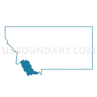
Outline

Summary
| Unique Area Identifier | 611821 |
| Name | Precinct 19 |
| County | Beaverhead County |
| State | Montana |
| Area (square miles) | 345.04 |
| Land Area (square miles) | 344.98 |
| Water Area (square miles) | 0.06 |
| % of Land Area | 99.98 |
| % of Water Area | 0.02 |
| Latitude of the Internal Point | 45.25623390 |
| Longtitude of the Internal Point | -113.08246050 |
Maps


Graphs
Select a template below for downloading or customizing gragh for Precinct 19, Beaverhead County, Montana


Neighbors
Neighoring Voting District (by Name) Neighboring Voting District on the Map
- Precinct 17, Beaverhead County, MT
- Precinct 2, Beaverhead County, MT
- Precinct 20, Beaverhead County, MT
- Precinct 23, Beaverhead County, MT
- Precinct 5, Beaverhead County, MT
- Precinct 8, Beaverhead County, MT
Top 10 Neighboring County Subdivision (by Population) Neighboring County Subdivision on the Map
- Dillon CCD, Beaverhead County, MT (7,880)
- Big Hole Basin CCD, Beaverhead County, MT (615)
- Clark Canyon-Horse Prairie CCD, Beaverhead County, MT (376)
Top 10 Neighboring Elementary School District (by Population) Neighboring Elementary School District on the Map
- Dillon Elementary School District, MT (7,757)
- Jackson Elementary School District, MT (152)
- Grant Elementary School District, MT (142)
- Polaris Elementary School District, MT (97)